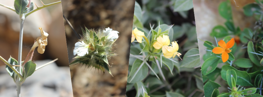
Oman geography
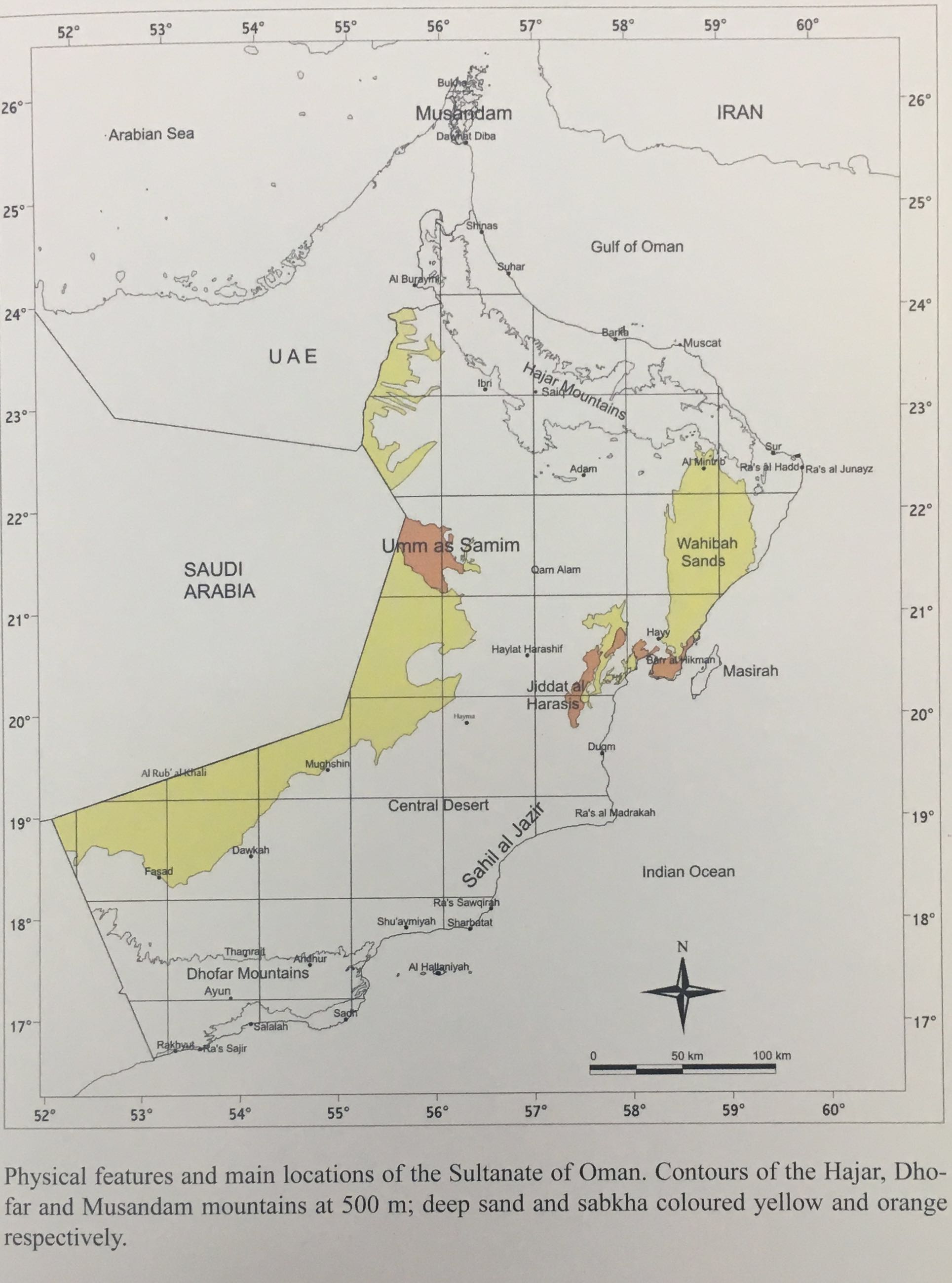
The Sultanate of Oman is located in the South Eastern tip of the Arabian Peninsula and has an estimated land area of 309,500 km2 and 1,700 km of coast (Al-Zidjali, 1995). Two continents, Africa and Asia influence the vegetation in Oman; Northern Oman has a vegetation type similar to the Flora of southwest Asia, while the vegetation in southern Oman is mostly related to the Flora of North and East Africa (Pickering & Patzelt, 2008). Many species are endemic to the country and depend on the different habitats and climate. Shahina Ghazanfar has published the first descriptive Flora of Oman – with two of four volumes published (Ghazanfar 2003, 2008); volume 3 is in press. Flora of Oman and the project on going with support from Kew garden, is a descriptive Flora of the native plants of the Sultanate of Oman, covering 1, 212 species of vascular plants found in the Sultanate (Oman Flora, 2015).

Vegetation of Sultanate of Oman
Description and delimitation of plant communities and associated vegetation of Oman have been described by, Ghazanfar (1991, 1999, 2003); Ghazanfar & Rappenhoner (1994); Mandaville (1977); Munton (1988); Frey & Kurschner (1986); Cope (2007); Feulner (2011); Patzelt, 2014 and 2015). Currently, a total of 1239 species of vascular plants and ferns have been found in Oman (Patzelt, et al., 2014). In northern Oman has been recorded about 51% from the total flora (at least 716 species), 254 species were found in Central Oman (18% of the total flora), and 58% of the total flora are represented in southern Oman with around 817 species in total (Patzelt, 2015).
Northern Mountains
The rugged Hajar Mountains in northern Oman stretch for 700 km, from the Musandam Peninsula to Ras Al Hadd in the east. The Samail Gap, through which the main north-south road runs, divides the range into the eastern and western Hajar. The Jabal al Akhdar range in the western Hajar reaches altitudes of over 3,000 m, with Jabal Shams (3,009 m) being the highest point. The annual rainfall here is approximately 350 mm, and falls mainly in the winter months. At lower altitudes, annual rainfall decreases to an average of 75 mm (Pickering & Patzelt, 2008).
The Jabal al Akhdar massif has been classified as a local centre of plant endemism. It belongs to the WWF’s Global 200 Ecoregion “Arabian Highland Woodlands and Shrublands”, an area that includes the Arabian Peninsula, Yemen, Oman, Saudi Arabia, and the United Arab Emirates (Olsen et al, 2001). This Ecoregion has a total area of 470,000km2 and has been classified as ecologically “vulnerable”. Around 60% of Oman’s 1204 species of vascular plants are found in the higher part of this area, above an altitude of 1,500m; 14 of the taxa are endemic to Oman (Ghazanfar, 1998).
Southern Mountains

The province of Dhofar lies in the extreme SW of Oman and consists largely of sparsely vegetated desert plain. However, there are ranges of limestone Mountains along the south coast, which are covered in a type of vegetation unique in Arabia. These mountains extend eastwards, in a crescent-shaped arc, for 290 km from the border of southern Yemen. The top of the range consists of a rolling plateau, dissected by deep wadis along much of its length; most of these average 800-900 m, but rise in the east to over 2100 m on Jabal Samhan. The Dhofar Mountains have many distinct zones of vegetation, which depend on climatic and topographical factors such as distance from the sea, elevation, aspect, soil type, and the amount of precipitation from mists or rain and monsoon (Ghazanfar, 2003). The zones include foothills, escarpment wood and grassland, dry plateau, and north draining wadis, as well as cliff, desert and pre-desert. The summit of Jabal Samhan is very dry and supports an open community of woody herbs, including the endemic subshrubs Lavandula hasikensis, Salvia hillcoatiae and Campylanthus pungens. Acacia etbaica trees are also found, and on the cliffs and in sheltered valleys there are Dracaena serrulata, and Pistacia falcata (Miller & Morris, 1988).
Wadis and Oases

The middle altitude (500-2,000 m) of the deeply incised valleys of the western escarpment shelter the richest Sudanian vegetation type found in Arabia. Wadis act as intermittent rivers, which form communication routes between villages while the oases are man-made, located where more fertile wadis and mountains have supported agricultural communities (Al-Zidjali, 1995). There are only a few endemic species in the wadi Flora, and the availability of annuals and perennials depends mainly on the amount of water during the year (Ghazanfar, 2003). The distribution of some wadi species such as Rhazya stricta and Jatropha pelargoniifolia, reflect the transition from a winter to a summer precipitation regime and from a climate with winter frost to one with a frost-free winter (Pickering & Patzelt, 2008).
Coastal areas
Oman coast is divided into two mainly coast habitat; first one characterized by sandy beaches and salt marshes dominated by halophytes and species associated with coastal dunes (Ghazanfar, 2003). The second one is steep rocky habitat along the coast. Nearly perennial, succulent and semi-woody dwarf shrubs present in the coastal area lined with the mangrove tree Avicennia marina or with reeds, Phragmites, reed mace Typha and other aquatic vegetation (Pickering & Patzelt, 2008). Ghazanfar (1999), classified the vegetation of Oman coast into four types as follow (1) The coastal vegetation of northern Oman characterize by Limonium-Zygophyllum community. (2) The north-eastern coast characterizes by Suaeda-Limonium community. (3) The Atriplex-Suaeda community is a typical vegetation of the offshore islands, flat sandy beaches and sabkhas. (4) The Limonium-Sporobolus-Urochondra community is distinguishing vegetation type of the southern coasts.
Gravel Deserts and Escarpment
This area includes the oil producing country, and the wide stony plain of the Jiddat al Harasis, home of the Harasis people and also of much wildlife. There is a depression lying east of the escarpment of the Jiddat al Harasis, known as Al Huqf. Formed by sea erosion, it is now a region of ‘Sabkha irregularly interspersed with higher ground. It has an unusual desert climate with thick fog banks and a mean annual rainfall of less than 50 mm, with the possibility of several consecutive rainless years. Estimated less than 200 species found in the central gravel desert from the total plants found in Oman (Ghazanfar, 2003). The vegetation consists mainly of tree scrub, principally Vachellia tortilis and Prosopis cineraria, both of which provide important fodder for livestock. There is also some sparse ground cover, mainly of members of the Chenopodiaceae and Zygophyllaceae families, with a few grasses (Pickering & Patzelt, 2008).
Sand Deserts

The central desert of Oman lies approximately between 18o 22o30’ N and 59o E, and occupies about half of the country’s land surface area. The sand desert vegetation is also varied, with the central desert being sparsely vegetated with a low diversity of species. It is estimated that it contains less than 25 % of the total species in the country (Pickering & Patzelt, 2008). The main vegetation consists of scattered Vachellia tortilis trees, large and small shrubs, and perennial grasses. The western edge of the desert adjoining the Rub’ al-Khali sands is predominantly marked by psammophilic vegetation. This consists of stands of Prosopis cineraria and Calligonum crinitum in areas where the dunes are stabilized and smaller shrubs such as Zygophyllum qatarense, Z. hamiense and Heliotropium kotschyi (Ghazanfar, 2003).
Roadsides and disturbed areas
This habitat is constantly disturbed by construction and settlement, and plants found here are usually pioneer or invasive species such as species of Launaea, Parthenium, Solanum, Pluchea and various grasses (Pickering & Patzelt, 2008).
